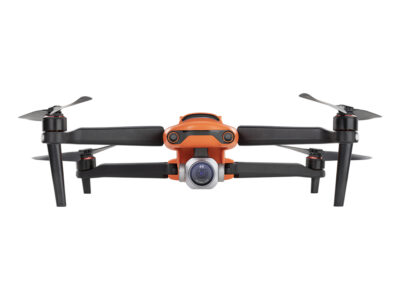


Quadcopter Autel EVO II Dual 640T RTK V3 Rugged Bundle
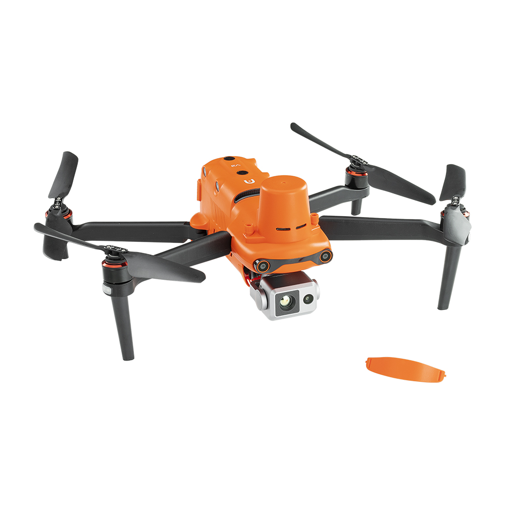
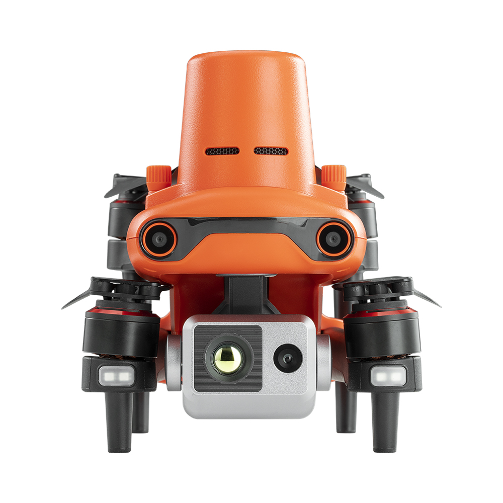
Autel EVO II Dual 640T RTK V3 is a drone that combines an infrared camera with an 8K video camera. With a thermal camera with a resolution of up to 640×512 and an 8K sensor, the EVO II Dual 640T RTK V3 becomes a reliable assistant and a compact tool that provides the necessary data at night and in poor lighting conditions. The quadcopter has an integrated RTK module for measuring and mapping down to the centimeter.
– 15 km data transmission range
– 38 minutes flight duration
– 10 palette of thermal colors
– The resolution of the thermal imager is 640*512
– 0.8-inch camera with an out-of-the-box CMOS sensor
– ADS-B receiver
– Positioning at the centimeter level
– Dynamic object tracking
– 360° obstacle avoidance
5299,00 €
Available on backorder
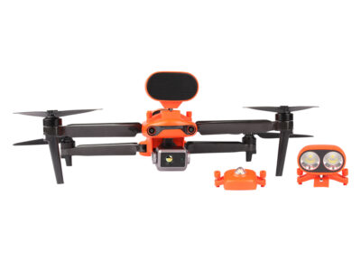
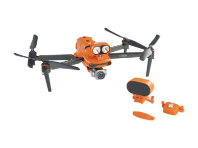
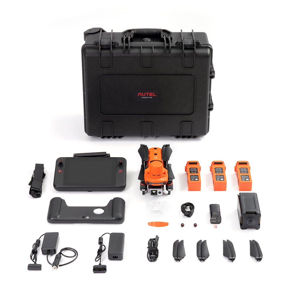
Complete set
(1) EVO II V3 Aircraft with Dual Camera
(1) RTK module
(3) Flight batteries
(1) 7.9 inch smart controller
(3) Pairs of propellers
(1) 110V wall charger
(1) 12V car charger
(1) Smart Controller charger
(1) Smart Controller charging cable
(1) Chest strap
(1) Suspension cover
(1) 32 GB SD card
(1) Spare pair of control knobs
(1) Rigid solid body
Unparalleled precision and control

Horizontal RTK positioning accuracy: 1 cm + 1 ppm
RTK vertical positioning accuracy: 1.5 cm + 1 ppm
POSITIONING ACCURACY TO THE CENTIMETER
The EVO II RTK V3 series now includes a new RTK module that guarantees positioning with centimeter accuracy within 3 minutes and supports PPK technology (kinematics in post-processing). The quadcopter can record satellite observation data, camera exposure parameters, and other data. The positioning system supports the RTK base station and the NTRIP RTK network, which allows for the most accurate data collection in difficult operating conditions.
No GCP Required
The EVO II RTK V3 connects to the NTRIP network and does not require a GCP to ensure centimeter accuracy.

Third-party base station support
The EVO II RTK V3 series supports all NTRIP compatible base stations.

Autel Explorer for Mapping
Saving multiple NTRIP profiles
The Explorer application allows the user to create and save multiple NTRIP profiles for different locations and avoid manually entering account information for each flight.
Exact repetition of settings
For repetitive data collection tasks, you can record previous positions of the quadcopter. The device will reproduce all the movements, as well as the settings of the stabilizers and the camera, which allows you to get a complete repetition of the entire flight task.
Flight missions with multiple charges
During multi-charge flight missions, the EVO II RTK V3 series returns to the last waypoint without restarting the route.< /p>

Advanced feature set

Create flight paths using straight or polygonal trajectories

Support dual grid mapping to create additional corners

Full manual control over camera settings

Saving time and battery resources thanks to constant cornering

The ability to adjust the course, taking into account all the user’s requirements for the position of the quadcopter in the air
DUAL CAMERA PRECISE TEMPERATURE MEASUREMENT
The EVO II Dual 640T RTK V3 model is equipped with a high-resolution thermal imaging camera and a brand new 8-inch 50MP RYYB sensor from Sony.
High-resolution thermal imaging sensor
The sensor has the highest resolution of high-definition thermal imaging 640*512 in the known production with a frequency of 30 Hz.
Precise temperature measurement
EVO II Dual 640T RTK V3 will most accurately determine heat sources at a distance of 2-20 m .Using an infrared temperature measurement compensation algorithm, the 640T RTK model can adjust the temperature deviation within 3 degrees Celsius.
New image processing algorithm
The V3 system uses a completely new image processing algorithm that makes thermal images clearer and more recognizable.

30 Hz refresh rate for videogrammetry
EVO II RTK Dual V3 provides a high refresh rate for accurate and detailed 3D heat maps.

Zoom in for details

A variety of color palettes
White Hot/Cold and Hot/Rainbow/Contrast Rainbow/Iron Rainbow/Lava/Arctic/Scorching/Gradation/Heat Detection


Compact design The EVO II RTK V3 series features a compact design for easy transport and deployment.

Simple process: 45 seconds from launch to take-off with the EVO II RTK V3 series.

Level 8 wind resistance.
EVO II RTK V3 series’ smaller cross-sectional area and powerful motors provide greater stability and control in any wind.< br />

38 minutes flight time.
Flight time is up to 38 minutes, which is 20-30% longer than the next main competitor. This advantage provides greater area coverage and longer missions.

Drone Zone*
The EVO II RTK V3 series has no pre-set drone zones, which will not interfere with the take-off*.

No updates required**
Unlike the competition, the EVO II RTK V3 series does not require the latest hardware or software to take off.


Operating temperature from -20 °C to 40 °C

Battery battery life 4.5 hours

Maximum brightness 2000 nits

Areas of application
Technical characteristics
AUTEL EVO II DUAL 640T RTK V3 QUADROCOPTER
-
- Weight at take-off: 1237g
- Diagonal wheelbase: 397 mm
- Size (LWH, with propellers): 230*130*143 mm (expanded) 457*558*143 mm ( collapsed)
- Maximum service altitude: 7000 m
- Maximum climbing speed: 8 m/s
- Maximum speed of descent: 4 m/s
- Maximum horizontal flight speed: 20 m/s
- Maximum flight distance (without wind): 21 km
- Maximum tilt angle: 33°
- Maximum angular velocity: 120°/s
- Maximum flight time (without wind): 36 min
- Maximum holding time in the air (without wind): 32 min
- Operating temperature range: -10℃ ~ 40℃
- Maximum wind resistance: 12.0 m/s
- Operating frequency
902-928 MHz (FCC only
2.400-2.4835GHz
5.725-5.850GHz
- Transmission power
900M
FCC/ISED: ≤31 dBm
2.4G
FCC/ISED: ≤32 dBm SRRC/CE/MIC/RCM: ≤20 dBm
5.8G (outside Japan)
FCC/ISED/SRRC/MIC: ≤33 dBm
CE/RCM: ≤14 dBm - Accuracy of holding in place
When RTK is enabled and working normally:
Vertically: ±0.1 m; Horizontally: ±0.1 m
With RTK disabled:
Vertically:
±0.1 m (with visual positioning in normal operation mode);
±0.5 m (with GNSS in normal operation mode) Horizontally: ±0.3 m (with visual positioning in normal operation mode);
±1.5 m (with GNSS in normal operation) -
Memory:
- Internal memory: 8 GB
- max. support 256 GB (requires UHS-3 rating)”
Remote control and image transfer:
- Operating frequency:
902-928MHz (FCC only)
2.400-2.4835GHz
5.725-5.850GHz
- Transmission power:
FCC: ≤33dBm
CE:≤20dBm@2.4G, ≤14dBm@5.8G SRRC: ≤20dBm@2.4G, ≤33dBm@5.8G/5.7G
- Maximum transmission distance (without interference, free from interference):
“FCC: 15 km
CE: 8km” - Display 2048×1536, 60 frames per second
- Battery 5800 mAh
Operating time ~3 hours (with maximum brightness) ~4.5 hours (with 50% brightness)
Charging time is 120 minutes - 128GB internal ROM storage
- Type of detection system: Omnidirectional detection system
- Forward:
Detection range: 0.5-18 m
Effective detection speed: <12 m/s Viewing angle: Horizontal: 60°, Vertical: 80°” - Back:
Detection range: 0.5-16 m
Effective detection speed: <12 m/s Viewing angle: Horizontal: 60°, Vertical: 80°” - Up:
Detection range: 0.5-10 m
Effective detection speed: <5 m/s Viewing angle: horizontal: 65°, vertical: 50°” - Down:
Detection range: 0.5-10 m
Effective detection speed: <5 m/s Viewing angle: horizontal: 100°, vertical: 80°” - Left and right:
Detection range: 0.5-10 m
Effective detection speed: <5 m/s Viewing angle: horizontal: 65°, vertical: 50°” - Operating Environment: “
Front, Back and Sides: Surface with clear pattern and sufficient illumination (lux > 15)
Top: Detects diffuse reflective surfaces (>20%) (walls, trees, people, etc.)
Bottom: A surface with a clear pattern and sufficient illumination (lux > 15) Detects diffuse reflective surfaces (>20%) (walls, trees, people, etc.)”
(1) EVO II V3 Dual Camera Aircraft
(1) RTK Module
(3) Flight Batteries
(1) 7.9 Inch Smart Controller
(3 ) Propeller Pairs
(1) 110V Wall Charger
(1) 12V Car Charger
(1) Smart Controller Charger
(1) Smart Controller Charging Cable
(1) Chest strap
(1) Hanger cover
(1) 32GB SD card
(1) Spare pair of control knobs
(1) Hard strong body